La situation météo générale durant les 2 nuits était chaud et humide. Les températures maxima du jour
précédent, les minima et maxima du jour suivant furent :
Date (Juillet 1952)
19
20
26
27
Ville
max.
min. - max.
max.
min. - max.
Washington
93 °F
76 °F
90 °F
90 °F
75 °F
94 °F
Norfolk
98 °F
78 °F
95 °F
89 °F
72 °F
98 °F
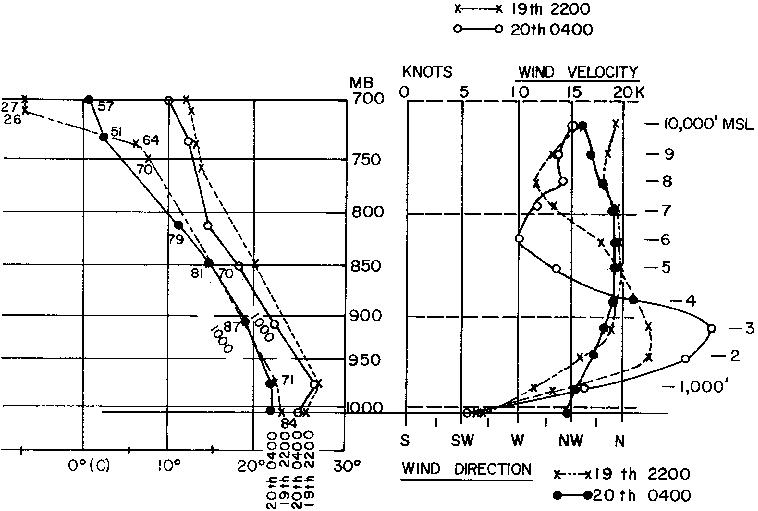
Figure 1 - Profils de température, point de condensation, humidité relative, direction et vitesse du vent liés aux
observations d'ovnis durant la nuit du 19 au 20 Juillet 1952 près de Washington (D.C.)
La nuit du au une grande et plate zone de haute-pression de 1020 millibars était
située au-dessus de la Middle Mississippi Valley et a very minor trough existed off the east coast. Il n'y avait pas
de fronts dans les régions immédiates de Washington ou Norfolk. Le flux d'air général était d'ouest en est.
Dans la nuit du au , Washington comme Norfolk étaient près du centre d'une flat
high-pressure wedge s'étendant du Texas à plusieurs centaines de miles à l'est de la ville de New York. Une
dérivation de l'ensoleillement du sud au nord caractérisait le flux d'air vers l'extérieur depuis le portion
centrale du wedge. Encore une fois, il n'y avait aucun front dans la région immédiate d'une ou de l'autre des
stations.
L'incidence de nuages épars
Il aurait été possible pour des observateurs au sol d'avoir vu de petits nuages à des altitudes basses et modérées
à divers moments lors de chacune des 2 nuits. Une certaine couverture nuageuse — principalement des nuages épars —
fut enregistrée par pratiquement toutes les stations d'observations où des observateurs formés étaient en service.
Un résumé des conditions de couverture nuageuse est :
A Washington dans la nuit du au 20juillet.
A l'observateur mentionna
quelques altocumulus à 8000 pieds. Ces altocumulus ne furent pas mentionnés dans les rapports suivants jusqu'à
le matin du 20 lorsqu'à nouveau dans la colonne de remarques quelques altocumulus sont
mentionnés. Le résumé horaire indique une altitude de ces nuages observés proche du niveau du Soleil à 18 000 pieds
et le mouvement du nuage depuis le nord-ouest.
L'observateur à Bolling AFB, just across the river de l'Aéroport National de Washington, enregistra diverses
quantités de middle cloud estimés à 12 000 et 15 000 pieds durant la première partie de la nuit avant 22:30. De tels nuages ne furent
pas signalés entre et . A 04:30 l'observateur en service à Bolling AFB signala des nuages épars à 14 000 pieds et quelques nuages cumulus à 5000 pieds. Les observateurs à
l'Aéroport National de Washington comme à Bolling AFB signalèrent diverses quantités de nuages cirrus à 25 000 pieds.
Figure 2 - Profils de température, point de condensation, humidité relative, direction et vitesse du vent liés
aux observations d'ovnis durant la nuit du 19 au 20 Juillet 1952 près de Norfolk (Virginie)
Aucun nuage bas ou intermédiaire ne furent signalés pendant la partie la plus sombre de la nuit. Il n'est pas
inhabituel que des observations faites par des observateurs formés lors de brefs sorties dehors depuis une salle
éclairée ne voient qu'un ciel obscurci, ne pouvant signaler des conditions de nuages épars. Un autre observateur
resté dehors suffisamment longtemps pour que ses yeux s'habituent à des conditions plus obscures peut souvent voir
des nuages épars. Les conditions nuageuses lors de cette nuit auraient laissé des nuages épars se former et se
dissiper en un intervalle de temps raisonnablement court dans une portion quelconque du ciel.
Il y
aurait pu avoir quelques nuages de visibles pour des observateurs au sol dans la zone de Washington bien qu'ils
n'aient pas été signalés par les stations d'observation officielles. Les nuits du au 20 et du au intervinrent pendant la portion la plus sombre
du mois, une pleine lune en juillet 1952, ayant eu lieu juillet.
A Norfolk dans la nuit du 19 au juillet.
Les conditions éparses à
4000 pieds et les quantités variables de nuages à à peu près 12 000 pieds aurait permit que quelques nuages épars
soient vus de manière intermittente à divers moments de la nuit.
A Washington dans la nuit du au 27juillet.
Des conditions claires y prévalèrent la
plupart de la nuit mais lorsque le jour commença à arriver entre et 05:00, des nuages furent signalés sous la forme de quelques stratocumulus à 2000 pieds et
quelques fins cirrus épars à 25000 pieds. Il aurait été possible que quelques nuages aient été visibles dans la
région pendant la portion la plus sombre de la nuit si un observateur avait permit à ses yeux de s'adapter à
l'obscurité.
A Norfolk dans la nuit du au 27juillet.
Les conditions nuageuses dans la région de Norfolk varianet
considérablement entre l'Aéroport Municipal de Norfolk et les observations faites à la base aérienne de Langley à
plusieurs miles au nord de là. Langley signala des conditions claires alors qu'une couverture de nuages plus ou
moins épars était signalée autour de 5000 pieds à l'Aéroport Municipal de Norfolk.
Il y aurait eu une
zone marginale de couverture nuageuse en dissipation quelque part entre l'Aéroport Municipal de Norfolk et la base
aérienne de Langley. Ainsi, des observateurs multiples auraient pu avoir une large variété d'observations de
nuages possibles.
Profils de température, humidité et vent
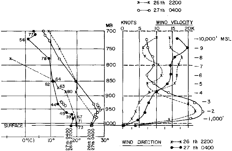
Figure 2 - Profils de température, point de condensation, humidité relative, direction et vitesse du vent liés aux
observations d'ovnis durant la nuit du 26 au 27 Juillet 1952 près de Washington (D.C.)
Les conditions atmosphériques étaient capables de générer une propagation anormale sur les écrans radar météo lors
des 2 nuits. Dans le livre de Battan sur la Météorologie Radar, publié en 1959, p. 21, on trouve ce qui
suit :
La radiation nocturne, qui intervient lors des nuits claires, en particulier en été lorsque le sol est humide,
débouche sur une inversion de température au sol et une diminution aiguë de l'humidité avec l'altitude. On trouve
que ces conditions produisent souvent une propagation anormale, qui devient plus prononcée à mesure que les taux
d'intervalles de température et d'humidité augmentent... Ces conditions qui favorisent les conduits au sol
interviennent le plus souvent au-dessus de grandes portions de terres l'été et peuvent être vues comme des
situations de "superréfraction radiative".
Des études plus récentes sur la propagation anormale sur radar ont été faites au Texas A & M. Elles ont en outre
confirmé l'apparition d'échos radar pendant les heures de la nuit et du début du matin par des conditions de ciel
clair lorsque des inversions de basse altitude et des quantités d'humidité fluctuantes caractérisent l'atmosphère
environnante.
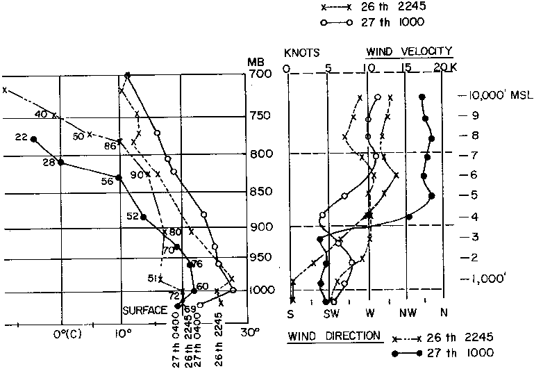
Dans les figures 1 à 4, les profils de température et du point de rosée, en plus des direction et vitesse du vent,
sont présentés. Dans la plupart des cas les profils verticaux près du sol auraient eu une variation de
plusieurs degrés dans et autour de chacune des 2 stations où les radars étaient situés. En utilisant les
températures de surface aux plusieurs aéroports et les observations radar effectives, il y aurait eu des variations
of from 3-5°F dans les premières quelques centaines de pieds. Un changement relativement faible dans les profils
verticaux aurait eu lieu pendant la nuit à des altitudes supérieures à 2500 pieds. Les pourcentages respectifs
d'humidité relative sont répertoriés à côté du profil d'humidité. Les lignes pointillées dénontent des observations
faites à . Les lignes pleines dénotent des valeurs à 10:00 le matin suivant. Les profils auraient changé progressivement dans les heures de la
nuit mais seraient restées quelque part entre ces 2 relevés. La plus grande variabilité dans la zone locale aurait
été dans les quelques centaines de pieds les plus inférieures. Près de la surface, des indications pour 04:00 furent faites à partir des observations de surface.
Figure 2 - Profils de température, point de condensation, humidité relative, direction et vitesse du vent liés aux
observations d'ovnis durant la nuit du 26 au 27 Juillet 1952 près de Norfolk (Virginie)
Tout de même important est le fait que des averses furent signalées dans la zone de Washington en fin d'après-midi
le juillet. Les quantités rapportées aux 3 stations de la zone de
Washington allaient de 0,10 à 0,13. Cela aurait humidifié le sol et fourni une source d'humidité variable dans les
différentes portions du pays environnant.
Résumé
L'avis de l'auteur est qu'un air chaud et humide prévalait lors des 2 nuits à Washington comme à Norfolk. Le temps
global aurait été considéré comme plutôt bon par les observateurs formés aux divers aéroports et ils aurait pu ne
pas signaler tous les nuages épars qui étaient en fait
présents. It would have been considered an "easy shift." Les visibilités restèrent au-delà de 6 miles à tout moment.
Le mouvement horizontal de nuages épars, en plus de la formation et de la dissipation de quelques nuages bas, auraient tous 2 pu être vus à divers moments
par des observateurs au sol dont les yeux étaient bien adaptés au sol obscurci. Une propagation anomale aurait pu
être observée sur les unités radar météo lors des 2 nuits dans les 2 endroits. Les échos dûs à une propagation
anormale auraient eu un movement horizontal similaire aux nuages.